A Visit to the Yellowstone
Park in the USA
My father inculcated in me a fondness for reading books at a very
young age. He introduced me to books on dinosaurs, plant fossils and volcanoes that captivated
my young mind and, consequently, one of the places on my bucket list was Yellowstone Park in the USA.
Although I’ve visited the United States several times since 1990, it was finally in May 2018 that my dream was fulfilled. My husband and I booked our tickets to tour Yellowstone Park, as part of our itinerary to the US. We landed in Seattle in the first week of May to visit our son, and on May 26, we took a flight to Bozeman Yellowstone International Airport from Seattle.
I had read much about this first national
park of the world. Established in 1872, Yellowstone Park is located in
the western United States, with its major part in Wyoming state, followed by
Montana and Idaho. When visited the park, besides enjoying the varied flora and fauna, taking photographs of the
park’s geothermal features like natural geysers, hot springs and waterfalls
held a great charm for me.
As the small Alaska airlines aircraft was landing at Bozeman International airport in Montana, I took photographs of the picturesque snow-covered mountains, surrounding
on all sides, so that I could share the mesmerising scenic beauty with all.
Landing at Bozeman airport in Belgrade, Montana
Landing at Bozeman on May26
Our tour operator welcomed us at the airport, from where we drove down to our hotel in West Yellowstone. The
drive through the national highway, alongside the Madison River, was simply
breathtaking.
Madison River on the way to Yellowstone West from Airport
We could actually feel the clean air in the lush surroundings, as we stopped on the way to take pictures,
and one of them is of the Big sky Silver Peak in the pristine landscape. Big Sky Silver Peak is located
approximately midway between Bozeman West Yellowstone on US Highway 191.
Took a diversion to see the Chapel and the Big sky Silver Peak
The Big sky Silver Peak in the distant background
Closer look of the Big Sky Silver Peak
An hour and forty-five minutes later, we reached the Stage
Coach Inn hotel in Montana. After refreshing ourselves, we walked down to a
nearby supermarket for some ready-to-eat foodstuffs, because we wanted to
retire early as we had to get up early the next day for the tour.
We also visited some of the souvenir shops around the hotel
The Dream Tour
To tour the nearly 9065 square km (3,500 square miles) Yellowstone
National Park, located atop a volcanic hotspot, we began first with a day-long tour of
the park’s Lower loop, entering by bus on May 27.
Yellowstone Park tour area is divided into Lower and Upper Loops and they both meet in the middle looking like the shape of eight on the map. Although three days were not enough to cover the entire Park, touring on these two loops gave us a beautiful experience of this natural volcanic hotspot. Those who are young and energetic can be on their own and can spend more than ten days exploring various aspects of the Park and also enjoy skiing, rafting and others
The lower loop is slightly shorter than the Upper loop and is about 155 km. We visited
Firehole Canyon, Fountain Paint Pot, Old Faithful Geyser, Old Faithful Inn, Yellowstone Lake and Lake Hotel, Mud Volcano, the
Hayden Valley, Grand Canyon of the Yellowstone and Gibbon Falls. We saw some wildlife species like bison, bears and elks.
The most enjoyed part of our lower loop trip was the thermal Geyser park--- Fountain Paint Pot and enjoy some of the pictures we took
It was a sight to behold rocky flats dotted with plumes of mysterious steam to bubbling
mud pots and geothermal pools in varied shades, from startling aquamarine to golden
red.
This is perhaps a unique feature of Yellowstone Park that contains
the largest concentration of geysers in the world, with approximately 10,000
active geothermal features.
Red Spout Fountain
Red Spout Fountain in action
Thriving and dead vegetation in the Thermal park
Clepsydra Geyser
I am sure you all enjoyed the Thermal park Fountain Paint Pot tour with me.
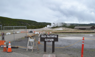
After finishing Fountain Paint Pot, our next stop was Old Faithful Geyser sight as our guide told us that the geyser would become active soon. Old faith geyser has naturally fixed timings and interestingly, the tour guides usually bring the tourists to witness at a given time.
Old Faithful Inn, with a beautiful Wooden structure
Our touring Bus
Old Faithful Geyser in action
Our next stop was the beautiful and huge Yellowstone Lake surrounded by snowclad peaks. We also went to Lake Hotel to have a cup of tea before proceeding to the next spot. The lake is situated at 2357 metres above sea level and is roughly 32.2 km long and 22.5 km wide with a 227 km shoreline and a surface area of 342 sq km, according to a US government report.
Our tour guide said, the lake freezes in winter and begins thawing only in May and early June. Even during summertime, the water is so cold that the survival time is estimated to be 20 to 3o minutes. so swimming activity is not recommended.
Yellowstone Lake
Yellowstone Lake Hotel
Then we stopped at Mud Volcano and Dragon's Mouth hot spring. Both Mud Volcano and Dragon's Mouth have reduced their major activity for the past few years we were told. However, we did see some activities in these two places. The Mud volcano was first discovered in the 19th century and the rumbling was heard half a mile away. It also shook the ground and flung mud onto the treetops, the guide said.
The Mud Volcano
Mud Volcano in action
Dragon's Mouth is a hot spring located to the left of just down the broad walk from Mud Volcano. The hot spring boiled out of a deep cave. Gases and steam were released into the cave which created bubbles that explodes against the roof of the cave. It gave an impression of smoke billowing from the mouth of a dragon!
Dragon Mouth Hot Spring
Grazing Bison in the Lower loop
Then we toured around the Grand Canyon of Yellowstone Park and Gibbon falls.
Lower Falls in Grand Canyon of Yellow Stone from Artist Point

My husband and me standing in the background of Lower Yellowstone falls
On the following day, May 28, we took a day trip to the Upper loop of Yellow Stone Park that is mostly with snow-clad peaks, the Lamar Valley, known for its population
of large animals, and the travertine terraces at Mammoth Hot Springs. The upper loop is a 229 km long circular track.
Our biggest attraction was Mammoth Hot Spring. We also got more than two hours to halt there to enjoy the place which was vastly different from other deep pools of water. Scientists say that over thousands of years, the hot mineral-rich water has bubbled up and formed layered pools and waterfalls.
It is a large Living Colour shimmering hot spring and billions of heat-loving micro-organisms--thermophiles thrive here. We had an opportunity to look at closely where these micro-organisms are living and prospering amid gases and heat that are lethal to humans.
Water and minerals have formed designs like terraces. They are steaming limestone terraces and grow daily.
Standing in front of Palette Spring at Mammoth Hot Spring
We also saw a 37 feet tall Liberty Cap at Mammoth Hot Spring. It is a huge dormant hot spring cone.
It was created by a hot spring that was active in one location for a long time.
Liberty Cap-a dormant Hot spring Cone at Mammoth Hot Spring
Then we went to the Albright Visitor Centre and Mammoth Hot Spring hotel for refreshment and
to buy souvenirs.
Deer relaxing outside the Mammoth Hot spring Hotel
A deer crossing the road outside Mammoth Hot spring Hotel
We were also taken around
Norris Geyser Basin, Grand Canyon, Dunraven Pass, Obsidian cliff and Tower fall. We got down only at Mammoth Hot Springs and Lamar Valley. At one place we had to wait for more than 20 minutes to give way to Bison which were crossing the road.
All the cars had to wait for the Bison to clear the way for us
We enjoyed the bus trip on the Upper loop and many places were covered with snow. Following are a few more pictures taken from the bus while touring the Upper loop.
On May 29, the third day of our Yellowstone Park trip, we were left on our own
and we visited the Discovery Park where orphaned wild bears, wolves are kept, a museum and other places outside the national
park.
Two Grizzly bears in captivity at Discovery Park are playing in the water
On May 30, we returned to Seattle.
On the way back to Bozeman International airport
Madison River at two different places on the highway way back to Bozeman airport
My visit to Yellowstone Park was a dream come true! Other places on my bucket list include a visit to Ladakh and Sikkim in India.


